Project Overview
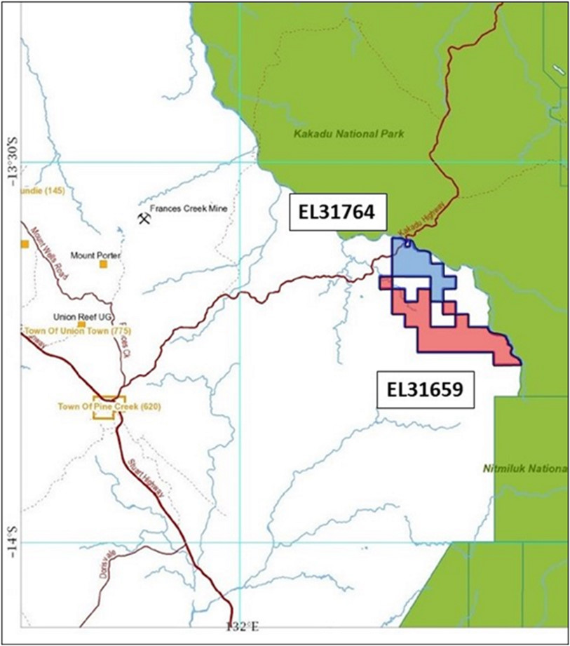
The Mount Davis Project consists of two of the eight NT Tenements (EL31764 and EL31659) and is prospective for gold and base metal mineralisation. The Mount Davis tenements, EL31659 and EL31764 are located about 45km north-east of the town of Pine Creek. Access is via the Kakadu Highway from Pine Creek and thereafter by gravel station tracks. The eastern boundary of the Project tenements lie along the Little Mary River which also delineates the Kakadu National Park to the east. The Mount Davis Project is located within the Mary River East Pastoral Station.

Figure 8: Location of Mount Davis Project
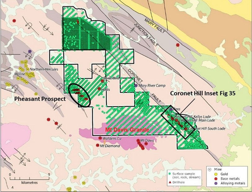
Detailed mapping around the Coronet Hill mines by exploration companies has revealed a complex setting. It was interpreted that the oldest sediments exposed are carbonaceous and lesser dolomitic mudstones of the Koolpin Formation, which are conformably overlain by mudstone, chert and albitic chert of the Gerowie Tuff Formation. Overlying these sediments are mudstones and BIF of the Mt Bonnie Formation, and then the Burrell Creek Formation.
The Mt Davis Granite intrudes the sequence, and the nearest edge of the granite is about two kilometres south-west of the main Coronet Hill workings. It has been interpreted from geophysical evidence that depth to granitic basement under the tenement is quite shallow.
Good outcrop is present along the creeks and on the crests of the ridges, while the hill slopes are covered with a thin veneer of near residual skeletal lithosols and colluvial/elluvial gravels. Transported soils are restricted to the main floodplain of the Mary River and to the lower portions of the larger tributary creeks. These conditions therefore provide excellent media for geochemical sampling exploration methods.

Figure 9: Mt Davis Tenements with Geology and Geochemical Sampling and Drilling Coverage
Historic mining and exploration along the Coronet Shear to the east of the Project area has targeted copper, tin and tungsten contained in a series of quartz veins. Exploration on the western part of the Project area has focused on gold exploration and some historical drilling conducted by Dominion Mining between 1993 and 1995 (at Pheasant) returned anomalous gold results.
Results from the first pass drilling at Pheasant (on 400m spaced sections) returned anomalous values on three of the four lines drilled. This equates to approximately 1,000m of anomalous strike length. Although no anomalous responses were recorded from the most northerly line a number of shallow pits and alluvial workings suggests that the trend may continue. The anomalous results are aligned north-west parallel to the local strike of stratigraphy.
The best gold results recorded from the first pass drilling, based on 10m composite samples, were:
- 10m at 0.49g/t (30 to 40m EOH) 94PHRC002;
- 10m at 0.58g/t (30 to 40m EOH) 94PHRC014; and
- 10m at 0.21g/t (0 to 10m) 94PHRC025.
All intersections correlate with abundant quartz veining ± silica and sericitic alteration ± pyrite.
All anomalous holes were re-sampled resulting in 35, 1m samples being assayed for gold, arsenic, bismuth, copper, lead, zinc and silver. The best gold results from re-sampling include:
- 94PHRC002: 6m at 0.43g/t (34 to 40m EOH) incl. 1m at 1.17g/t from 38m;
- 94PHRC014: 4m at 2.73g/t (36 to 40m) incl. 1m at 2.42g/t (36 to 37m) and 1m at 12.3g/t (38 to 39m EOH at 40m); and
- 94PHRC025: 2m at 0.39g/t (3 to 5m).
A compilation of several different sampling programs taken over more than 20 years (including a recent 2013 sampling program) clearly shows the anomaly in the western part of the tenement. However, it is recommended that a levelling process be conducted on the data to ensure that the different programs can be directly compared with each other.

Figure 10:Geochemical Sampling over Mount Davis Project showing Gold Results
Previous exploration has delineated a significant gold anomaly in the western part of the Project area. This has been followed up with wide spaced RC drilling with significant gold mineralisation intersected in some holes. The Company proposes to continue gold exploration with additional drilling.
Previous drilling has intersected significant base metal mineralisation along the Coronet Fault. This drilling has intersected massive and disseminated sulphides so it is anticipated that geophysical surveys may be a useful exploration tool to delineate additional massive sulphide mineralisation

