Project Overview
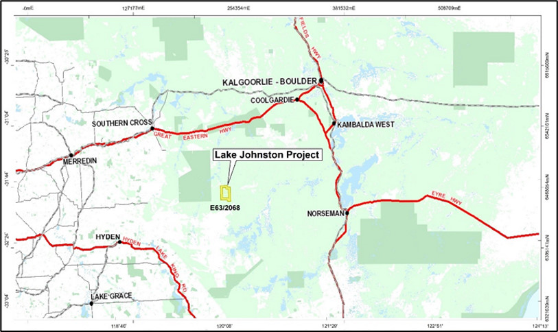
The Lake Johnston Project is prospective for nickel sulphide mineralisation and located in Western Australia. Access to the Lake Johnston Project is via the Great Eastern Highway from Perth to Southern Cross (340km) then south to Marvel Loch (34km) and then via the gravel Banker Mt Day Road to the tenement area (89km). Alternatively, access is via the Brookton Highway from Perth to Hyden (305km) and then along the Hyden-Norseman Road for 152km and then north on the Banker-Mt Day Road for 35km (Figure 11).
The Lake Johnston Project lies within the southern portion of the Southern Cross Province between the Lake Johnston greenstone belt and the main Forrestania greenstones of the Archaean Yilgarn Craton. The northwest trending belt extends over a strike length of approximately 35km and a maximum width of 8km. The region area is underlain by numerous locally intrusive granitic intrusive rocks of Archaean age and basement granitoids and gneiss, frequently incorporating rafts of highly deformed and metamorphosed greenstone lithotypes. These small, isolated greenstone rafts are the target of the proposed exploration in the Lake Johnston Project.

Figure 11: Location of Lake Johnston Project
Two prominent Proterozoic dykes cross the region, the largest being the Jimberlana Dyke roughly along the Hyden to Norseman road and the Binneringie Dyke passing near the Bounty Mine and through E63/2068. Thirty-six kilometres to the south-east are the now closed Emily Ann and Maggie Hays nickel mines. These deposits produced about 11.5Mt at 1% nickel, containing 112,500t of nickel metal. The mines and nickel concentrator are owned by Poseidon Nickel Ltd (ASX:POS) and are currently on care and maintenance.
Outcrop in the Project area is poor but regional aero-magnetics show a possible continuation of remnants of the Lake Johnston greenstone belt beneath the sandplain cover.
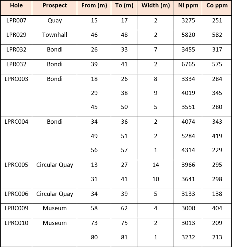
Recorded exploration begins in 1986 to 1989, which was conducted by Samantha Exploration NL. The target was gold, so no nickel assaying was completed, but some base metal assays, including platinum, were completed, which allowed potential nickel sulphide environments to be identified. Between 2003 and 2005, drilling by Western Areas NL confirmed anomalous nickel geochemistry to be related to weathering zone enrichments at two out of five targets (Bondi and Town Hall). Significant results from this drilling program are contained in the table below.

During July 2005, Image Resources engaged Southern Geoscience Consultants to carry out two lines of surface pulse electromagnetic surveys over the Bondi and Town Hall prospects.
The prospect was reviewed, and it was concluded that the weak to moderate EM response was not sufficiently compelling to justify the expense of testing by diamond drilling. The samples for LPRC011 were not assayed.
Conventional fixed loop TEM (FLTEM) surveys at the Bondi and Town Hall Prospects within the Lake Johnston Project were completed during July 2005. In total, 497 FLTEM stations were recorded for a total of 23.55 line km of data (four fixed loops and 26 survey lines). A possible broad, weak bedrock anomaly was defined in the southern central section of the Bondi Prospect. This possible anomaly was well defined in both the LPB1 and LPB2 loop datasets. Model results highlight the presence of a possible bedrock conductor at >100m depth.
Previous exploration on the Lake Johnston Project has delineated anomalous nickel mineralisation. EM surveys did indicate potential for sulphide mineralisation

